(Well Not Pyro's Project but usefull info)
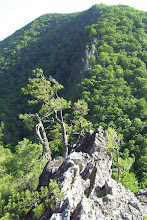
Buzzard Rock is a comparatively unused climbing area near Front Royal, VA. It offers some excellent slab climbing. Most routes can be led with a mixture of existing bolts and smaller pro (like Aliens). All of the routes can be top roped. The slab offers excellent climbing but be forewarned that because the rock doesn't get much use, it can have a build up of lichen in places.
Links-
Topo map to get you in the area. Click here
Climbing area map to help find the routes. Click here Note: click on the climb to see a photo.
GPS Users- downloadable GPS Coordinates. Click here
Driving directions-
Take I-66 West to Route 55 West towards Front Royal. Stay on 55 West until the town of Waterlick. Turn left onto Powells Fort Road (Route 678). Drive about 1.2 miles on 678 then turn left onto Mountain Road (Route 619). You will pass a fish hatchery. Stay on the road for 1.2 miles. You will come to a Buzzard Rock trailhead parking lot on the right. Pay attention cause it's easy to miss. Drive time from the Sport Rock III gym in Sterling to the trailhead is about 90 minutes in light traffic.
Approach-
It will take about 45 minutes to walk in using the white-blazed trail that leads up from the trail head parking lot. Follow the white blazed trail in for about 1.5 miles. The trail is well marked and doesn't get steep until the last part. You'll know you are close when you negotiate a switchback where you can see to the north for miles & miles. From there you have about 430 meters to walk along the trail to the beginning of the climbing area.
Finding the routes-
While the white-blazed ridge trail parallels the rock, some of the routes are not immediately obvious from above.
If you are new to the area, you can try spotting bolts from above or you can print the map and move to the base of slab. There's an unimproved, unblazed trail that connects the climbs along the bottom. From the bottom you can use the map to figure out what route you are looking at.
Misc-
Bring a 60 meter rope
You don't need a big rack to lead out here. The routes are very friendly to those just learning to lead.
Bring your own water. There's none on the ridge.
Nearby Passage Creek makes for a nice dip in the water after climbing.
If you are new to slab climbing don't be fooled by the angle of the rock. It looks easy but it ain't. The finger holds tend to be smallish. Upper body strength counts for very little here and it's all about precise footwork. The dry, powdery lichen will also make you pay attention to how you place your feet.
If you are going to top rope, I recommend a top belay with a grigri.
TOPO! GPS Data Format DegMinSec NAD83 ElevFeet UTC-Time
ALUM TUBE,38,56,30,-78,18,8,1245,07/18/2004,14:29:42,
ANON FLAKE,38,56,27,-78,18,9,1201,07/18/2004,14:29:43,
BUZ RK END,38,56,22,-78,18,12,1370,07/18/2004,14:29:43,
BZ RK BEGN,38,56,33,-78,18,5,-6450,07/18/2004,14:29:43,
BZ RK PRK,38,56,16,-78,17,19,-6450,07/18/2004,14:29:43,
KEEP OFF R,38,56,28,-78,18,9,1231,07/18/2004,14:29:44,
KIMBERLY,38,56,31,-78,18,8,1194,07/18/2004,14:29:45,
LONG SLAB,38,56,30,-78,18,8,1226,07/18/2004,14:29:45,
PRAJAPATI,38,56,23,-78,18,13,1311,07/18/2004,14:29:45,
PULP FRICT,38,56,32,-78,18,6,1181,07/18/2004,14:29:45,
RAISING AZ,38,56,32,-78,18,7,1204,07/18/2004,14:29:45,
ROCK FIN,38,56,23,-78,18,11,1341,07/18/2004,14:29:45,
UNK NO1,38,56,33,-78,18,6,1220,07/18/2004,14:29:46,


No comments:
Post a Comment