Friends,
I have been a Hoot-N-Aboot in a place called Smoke Hole. It seemed to be a busy weekend for the old gorge, in a Smoke Hole sort of way. All of the campers and the cabins seemed to be occupied and a handful of fishermen seemed to be out along the river. I saw many trucks with floatation devices of all types from the pool floats to old inner tubes. Their seemed to be an abundance of beverages flowing all about. It is my guess these where brought in to make up for the lack of water in the river. The entrance walls looked to be getting a little traffic in the last few weeks, besides my own. The trail seemed to be getting enough traffic to keep the weeds down.
The purpose of my trip into the area was to see the dragon and let it know that I’m still thinking about him. I men after all it has been a while since I have been to visit him after all. So I drove up through the valley, Smiled as I passed William and looked up at the Eagle. I thought about the good times that have been had under his ever watchful eye. I thought of the story of him climbing the rock that carries his name and what it must have been like on the first trip up that rock that now bares his name. On down I went past the low water bridge hung a left past Shreve’s store and started my climb up the mountain. On past the old saw mill, wondering if this was the same place that had employed the town of Smoke Hole in a time gone past. Then it was further up, always going higher, on past the winter camp where Ronin and I spent the night in freezing temperatures and in anticipation of our first time into the area of the Mushroom Towers. Arriving at the top of the mountain I was thinking about how the mountain had looked that morning after the snow with the ice hanging from the trees.
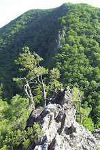
So here I stand, on the edge of the road, looking downward, searching through the receases of my mind looking for the way. I draw my trusty machete and proceed down into the abyss. As I cut my way through the greenbriers and rhodo. I keep heading down and clearing trail as I go. One hundred feet, two hundred, I’m heading down into the darkness now. There has been thunder for the last several minutes, the skies have darkened and the clouds have rolled up the mountain, you can't see down into the valley now. You can smell the rain coming, but I am so close now, I can see the trees dropping away in front of me, I have reached the head wall, before me stand's the open expanse with the mushrooms staring back at me. It is a rough trail I think, but it is a trail. If I continue any further I am going to be starting down into the playground that is the Dragon's belly, which is not the place that I want to be as the storm rolls in I turn to head back up the mountain. As I'm turning away it is with a promise that I will be returning soon. Almost as soon as the thought went through my head I saw two things almost simultaneously, a perfect campsite at the base of the head wall and a huge flash of lightning. Is it a sign? If it was then I don't know what it means, to see a campsite and at the same time the anger of the weather. It left me feeling slightly empty inside for some reason.
On my way out of Smoke hole, the storm that rocked the high ground but strangely seemed to leave the canyon floor alone was just a memory and had passed I saw some new climber's that were working on something on the far side of the river. They were directly across from a cabin that is just passed Eagle. It is kind of funny that I saw them here on my way out as I had looked at the corners on this rock on my way in thinking that they would be fun to check out in the future. It would seem that there is someone else playing in this particular sandbox right now. I have seen the gear bags in the past but this was the first time that I could actually see someone else out on the rock.
Stay tuned for the continuing story as the dragon is greeted and an accord is reached.
P
About Me
- Pyro
- I am who I am. Don't try to change me, It won't work! Like me, love me, or get the hell out of my way! I have been described as an opinionated asshole in the past. Mostly by people that didn't like hearing what I had to say. I have also been decrribed as a very good friend to have when your butt's in the fire. If you are still reading this then maybe one day you will see that side of me, as you have passed the first test, you have listened.
Saturday, September 3, 2011
Friday, August 5, 2011
Thursday, August 4, 2011
Thursday, July 28, 2011
Seneca By Grade
Seneca Rocks
5.0
East Face to Gunsight
Gurt’s Grungy Gully
Gunsight to North Peak
Pine Tree Traverse
West Face to Gunsight Notch
Worrell’s Thicket
5.1
Great Chimney
Oh Pooh
Pooh’s Corner
Reverse C
5.2
Christopher Robin
Expotition
Jane’s Route
No Dally Alley
Old Ladies Route
5.3
Heffalump Trap
Heffalump trap Direct
Humphrey’s Head
Old Mans Route
Question Mark
Roux
Skyline Traverse
Up Front
5.4
4 Me
A Christian Delight
Apricot
Cardon’s Rib
Cockscomb Pine Tree
Conn’s West
Ectasy Junior
Exit From the Victim
Gunsight to South Peak
Isadora’s Run
It Ain’t the Meat
Kauffman-Cardon
Kauffman’s Rib
Le Gourmet
Long Leggedy Beasties
5.4
Mistaken Identity
Up and Coming
Vegtable Variation
Windy Corner
5.5
Bear’s Delight
Cockscomb Chimney
Conn’s West Direct Finish
Easy Over
Eeyore’s Tail
Gunsight Notch East
Gunsight to South Peak Direct
Hero Pendulume
Irony
Jankowitz-Kamm
Lady Elaine
Lemur
LSD (lower skyline direct)
Penatoidal Membranes
R2D2
Sally’s Peril
Southwest Buttress Variation
Thais Escape
Traverse Pitch
5.5
Wap Suck
Wap Suck Direct
Wind Up
5.6
2nd Time
Banana
Banana Down Under
Candy Corner
Cockscomb Overhang
Conn’s east
Critter Crack
Dirty Hairy
Dirty Old Man
Disccontent
Finger Lichen Good
Front
Grandiose
Heartburn
Initiation
Le Gourmet Direct Start
Mrs. Robinson
One Stop
Planet Gong
R&R
5.6
Rox Salt
Roy Gap Chimney
SJM Ecstasy Connection
SJM Traverse Finish
Soler Escape
Thais
Tony’s Nightmare
Vision
Wolery
5.7
Amazing Grace
Appendictis
Bee Sting Corner
Blue Eyes
Breakneck
By-Pass
Clarke’s Climb Direct Finish
Cockjob
Conn’s West Corner Start
Craving for Pink
Crispy Critter
Debbie
Dirty Rat
Dufty’s Popoff
5.7
Ecstasy
Expletive Deleted
Flying Teapot
Fragmatist
Gephardt Duffty
Good Morning
Green Wall
H&H
Hang
Herpes
Horrendous Traverse
Into the Mystic
Keds
Lazy Daze
Low Rise
Midway
Neck Press
Pentatoidal Membranes
Pleasant Overhangs
Poor Man’s Critter
Promiscuity
Prune
Rappel Downs Horserace
Really Flaky
Rhododendron Corner
5.7
Road Kill
Roof Traverse
Scuttle
Seldom Seen
Simple J. Malarkey
Snakebite
So What
Soler
Stoney’s
Thais Direct Direct Finish
Traffic Jam
Victim
West Pole
Z Hole
5.8
Alcoa Presents
Block Party
Boardwalk
Burn
Burrito Man
Captain Trivia
Conn’s East Direct Start
Day of Future Past
Discrepancy
5.8
Famap
Fear of Flying
Finger Stinger
For Slab Rats only
Lichen or Leave it
Lox
Nova
Old Timers Luck
Peach
Praying for the Aliens
Quit Dogging the Scene
Rasp
Rear Entry
Rolling Rock
Scrambled Leggs
Seneca Trail
Shambler
Short Stuff
SJM Cave Start
SJM Overhang Finish
Springtime
Talk Dirty to Me
Tapps
Tomato
Triple S
5.8
Triple S Direct Finish
West Pole Direct Finish
Ye Gods and Little Fishes
Wednesday, July 27, 2011
A re-visit of Bear Haven and poor bolting
I stumbled upon this video when I went to youtube. It brought to my mind again how easy it was to pull the bolts their. Which also reminds me, I need to go back up and see if the bolt & hanger fairy has brought ma any more hardware yet.
Monday, July 25, 2011
http://www.indiegogo.com/Dan-Osman-The-Real-Life-Spider-ManPlease check the link. It will show you an amazing man and the love of a daughter
Monday, July 4, 2011
The Road Most Traveled
The Road Most Traveled
There is a road in Life;
It is the road Most traveled;
A road of Comfort and Familiarity.
Created with Caution;
Paved with Planning;
Groomed with Purpose;
Kept with Care.
Every step Measured;
Foreseen and Expected;
Taken with Certainty;
Every step, Known.
The road of life…
There is a road in Life;
It is a road Least traveled;
A road of Unease.
Created with the Wind;
Paved Extemporaneously;
Groomed with Indifference;
Kept with Relinquishment.
Every step Adventurous;
Foreseen and Unexpected;
Taken with Heart;
Every step, Breathed.
The road of living…
There is a road in Life;
It is the road Most traveled;
A road of Comfort and Familiarity.
Created with Caution;
Paved with Planning;
Groomed with Purpose;
Kept with Care.
Every step Measured;
Foreseen and Expected;
Taken with Certainty;
Every step, Known.
The road of life…
There is a road in Life;
It is a road Least traveled;
A road of Unease.
Created with the Wind;
Paved Extemporaneously;
Groomed with Indifference;
Kept with Relinquishment.
Every step Adventurous;
Foreseen and Unexpected;
Taken with Heart;
Every step, Breathed.
The road of living…
Saturday, June 18, 2011
Pat's Bones
Here lie the remains of Pat's bones,
Smashed to pieces on the stones.
That 5.11 was way over his head.
So he slipped and fell. Now he's dead.
But as he tumbled through the air,
He closed his eyes and said a prayer.
"Oh Lord, please when I hit the floor
I pray my soul to fall some more.
For when I start my final climb,
To finish at that throne of thine,
I wish the multi-pitch to take.
Not be top-roped off the Pearly Gate."
And so he fell but didn't land
'Til he reached the dwelling of the damned.
Then he upped and bid Old Nick farewell
And started climbing out of Hell.
It's now all uphill whiche'r route he take.
And yet we hope for Pat's sake,
That the grading of his route to Heaven
Is somewhat less than five-eleven.
Climb On!
Thursday, June 16, 2011


Thursday, June 9, 2011

Sunday, May 29, 2011
The new project begins!
So this is the start of my new project, it is called Skyline Traverse. When it is done it will work its way down to the end of the fin. It will also be the access point to the top of all the routes on the fin. Was a good day of climbing work after a full morning spent cranking on the Southern Piller. Weather was beautiful with bluebird sky's and the smell of rhodo in bloom mixed with the slightly surfuric smell of rock.


Wednesday, May 25, 2011
Thursday, May 19, 2011
Undocumented Linville Gorge Hikes: The Rock Jock Trail and Looking Glass Photos


Undocumented Linville Gorge Hikes: The Rock Jock Trail
By Bob Underwood
Hike this trail at your own risk. I only claim that i have hiked thru all this stuff at one time or another and survived. There is no guarantee that You will! ~Bob~
Hike this trail at your own risk. I only claim that i have hiked thru all this stuff at one time or another and survived. There is no guarantee that You will! ~Bob~
ROCKJOCK TRAIL (RJT) (247)
Unposted,partly published, Hiking and scrambling.
The Rock Jock Trail (RJT) is not maintained by the FS even though it is on their map. It is hardly mentioned in any current guide book, so here we are going to give it more attention.
Unposted,partly published, Hiking and scrambling.
The Rock Jock Trail (RJT) is not maintained by the FS even though it is on their map. It is hardly mentioned in any current guide book, so here we are going to give it more attention.
HIKING: the south end (DKR) is backpackable north up to Pinchin. From CC, the RJT is backpackable south to Hackers point which is north of Bluejay canyon. That means that the middle third of RJT is pretty much a Scramblers trail. This is the roughest and prettiest section. Theoretically, this does not have to be a rough trail. The few places it IS rough could be easily rerouted. It could be one continuous smooth trail except the part that skirts around Mossy canyon. Since it is not maintained, neither by hikers nor by the FS, it has become overgrown in some places and well traveled in others. In fact it is so overgrown that a dramatic , rough section has been lost and been replaced by an easier and less scenic 'shortcut'--and now the 'shortcut is the established trail. (Call this lost section RJT-LOST ie LOwer Original Scramblers Trail. Neat acronym huh?
TRIP REPORT:
I camped at North Rockjock and found that the trail is almost nonexistent. Even when you know exactly where it goes,it is still difficult to follow. Didn't see much of it--the purpose of the trip was to check out Buzzard's canyon to see it it would be possible to backpack thru it..and the answer is Yes. The canyon itself is not spectacular, but the surrounding rock formations sure are. There is a small Low -vol waterfall pouring thru a crack in the south wall. A car sized chock stone sits atop the crack. Probably just a damp spot in summer. From the base of this fall it ought to be possible to diagonal down to the river smoothly and without obstacle.
I camped at North Rockjock and found that the trail is almost nonexistent. Even when you know exactly where it goes,it is still difficult to follow. Didn't see much of it--the purpose of the trip was to check out Buzzard's canyon to see it it would be possible to backpack thru it..and the answer is Yes. The canyon itself is not spectacular, but the surrounding rock formations sure are. There is a small Low -vol waterfall pouring thru a crack in the south wall. A car sized chock stone sits atop the crack. Probably just a damp spot in summer. From the base of this fall it ought to be possible to diagonal down to the river smoothly and without obstacle.
A scout troupe from Raleigh came out Conley Cove. Their plan...???...had been to hike from Pinchin up Spense to Table Rock and back. They reported massive downage along the river. I gave em a ride to their vehicle at Pinchin.
Sunday we hiked down Babel to explore the Avatar's rib area. Once we got off-trail, it was Rough going. Imagine an ant trying to push thru a Brillo pad and ya get the idea! e finally broke thru the tangle into a natural clearing atop 40 ft cliffs....and what a Great view!! WE looked down on a bend in the river as it passes thru a rock canyon. Avatars rib was in sight...there appeared to be a way to the base of these cliffs .. which POSSIBLY would allow you to connect to Henson Creek. Even if this connection doesn't work, the Campsite is SO nice, it is worth the effort to find a way in to it. No water. No sure evidence of previous campers.
I had shoe problems and that stopped further exploration. There appears the faintest of trails which took us back to the top of Babel Tower Hill and on out to the KMH.
I had shoe problems and that stopped further exploration. There appears the faintest of trails which took us back to the top of Babel Tower Hill and on out to the KMH.
ROCKJOCK (NORTH)
The fire, ice storms, blight and fallen tees have made the RJT north of Conley cove so difficult to follow that even if you know exactly where the trail runs , it is still hard to read.
Conley cove is the north most entrance on this trail though it continues further north almost to Wiseman's View.
for the record, here's how to find it...?....and good luck! Go down Conely about 50 ft. There will be a camp / clearing on your left with a big fire pit. Turn into the woods angling at 2:00 o'clock.( you pass a smaller fire pit ) an in about 20 ft you hit a once-clear trail. This is all less than 100 ft north of CC. A pine has fallen into this trail ( head toward you ) and obscured it so if you skirt thru the bushes around the pine you might be able to intuit your way along. The trail goes gently downhill and enters a clear area, a sort of valley /gully and continues up the other side. This gully is the head of Buzzards canyon. ((Don't try to get into the canyon by going directly down the gully, there's a better way-- to be described later)) . North rockjock is not on cliff edge except in a few places. It ambles gently along the edge of a steep hillside ...gradually gains elevation and turns right into a long level clearing. The forest overhead is rotted pines. At the end of the clearing, RJT(N) turns sharply to the left and sort of zig zags down to a point. Halfway down the zigzag it contours sharply left...so what looks like the main trail is actually a cul-de-sac onto "Lone Wolf Point".Great camping, great view,no water.
for the record, here's how to find it...?....and good luck! Go down Conely about 50 ft. There will be a camp / clearing on your left with a big fire pit. Turn into the woods angling at 2:00 o'clock.( you pass a smaller fire pit ) an in about 20 ft you hit a once-clear trail. This is all less than 100 ft north of CC. A pine has fallen into this trail ( head toward you ) and obscured it so if you skirt thru the bushes around the pine you might be able to intuit your way along. The trail goes gently downhill and enters a clear area, a sort of valley /gully and continues up the other side. This gully is the head of Buzzards canyon. ((Don't try to get into the canyon by going directly down the gully, there's a better way-- to be described later)) . North rockjock is not on cliff edge except in a few places. It ambles gently along the edge of a steep hillside ...gradually gains elevation and turns right into a long level clearing. The forest overhead is rotted pines. At the end of the clearing, RJT(N) turns sharply to the left and sort of zig zags down to a point. Halfway down the zigzag it contours sharply left...so what looks like the main trail is actually a cul-de-sac onto "Lone Wolf Point".Great camping, great view,no water.
To continue, retrace back uphill and look for the trail coming in on your right. RJT(N) contours around a valley, gains elevation but stays on contour around a hill, continues around another valley ( a few hundred feet from the KMH at this point ) and comes out to a ridge. The RJT(N) continues up ridge but if you go down ridge a short distance you come to an outcrop: Window Rock. NEAT!! None of this was ever easy going-- and NOW i suspect it is outrageous. Everything sounds so easy in print. Theoretically, this could be an easy hike- even backpackable. It is generally on contour, no real climbs or scrambles but now this trail will fight you every step of the way. To me, Window Rock is sort of a sacred spot-- i almost hate to share it. PLEASE walk softly here! Please DONT camp.
Beyond WR, the RJT(N) goes up ridge a short distance and turns right skirting around a gully /valley and up a rocky ridge. It makes a sharp left down into another valley and follows that valley stream to its waterfall: Hummingbird Falls. Beyond this point, i have not found clear traces of the trail..The woods is fairly clear ( pre fire) and it is a short distance to Wiseman's .
Rock Jock Trail Entrances:
UPPER ENTRANCE:
This one is well known. From the parking lot go down trail about 800ft. Look for a trail going slightly uphill on the right. You are walking parallel to a small seep/stream Follow this trail till it comes to a clearing. Beyond the clearing stay parallel to the stream for maybe 200ft. You come to an intersection with another trail--this is Rockjock. Turning left(south) puts you on the main trail which leads all the way to Dobson Knob Road. Turning right leads back to the KMH which is only a few hundred feet away. Since you now know where this "southern entrance' comes out on the road, you can come in this way next time - saves maybe a thousand feet..
This one is well known. From the parking lot go down trail about 800ft. Look for a trail going slightly uphill on the right. You are walking parallel to a small seep/stream Follow this trail till it comes to a clearing. Beyond the clearing stay parallel to the stream for maybe 200ft. You come to an intersection with another trail--this is Rockjock. Turning left(south) puts you on the main trail which leads all the way to Dobson Knob Road. Turning right leads back to the KMH which is only a few hundred feet away. Since you now know where this "southern entrance' comes out on the road, you can come in this way next time - saves maybe a thousand feet..
ROCKJOCK ENTRANCE --LOWER
From the parking area at Conley Cove, go down trail passing the upper entrance. You will hit a series of switchbacks about 8 min from KMH. The tiny creek crosses the trail. Continue a few feet more to the next elbow turn and instead of turning, head straight uphill. In about 100ft you come out on a small outcrop overlooking the Conley creek valley. From this outcrop a trail continues uphill switching back to gain a ridge. If you follow the spine of the ridge uphill, you come out east of Lost Dog Pond and wander along the edge of the cliffs thru a windswept clearing of pine needles and moss.(( A connecting trail between upper and lower Rockjock passes around the pond. There is a campsite at this intersection --often trashed.)) Continuing along the edge, you cross a small trickle and hit another trail. If you go up(right,north) you reconnect with upper rockjock. The left turn takes you down to a spectacular viewpoint looking into Fern canyon 300ft below. The Lower trail has all the views but it is hard to follow...also you lose elevation to regain it later.
If you get to the overhung campsite on CC you have missed the lower entrance of JT--gone too far.
RJT-LOST 2
RJT-LOST runs parallel and below the RJT along a ledge from Bluejay to Zen canyons. Unposted unpublished. It is a SCRAMBLERS trail!
HOW TO FIND IT:
Without a GPS, these directions are hardly adequate--but ill try:
Without a GPS, these directions are hardly adequate--but ill try:
You are going south. You pass around Fern Canyon, and come out on a view at HACKERS point. The RJT turns south and gently downhill .Backpacking beyond this point is ROUGH. By following close to the edge you drop below the wall and walk beside a long water seepage. you enter the dry rocky stream bed of Bluejay canyon. If you stay on contour, you follow the stream bed uphill and take a SHARP left gaining elevation and passing thru a split rock.( OR if you don't stay on contour, you scramble up the south side of the stream /gully and come out on the east end of the cracked rock..). Now you are on the south side of Bluejay canyon headed east. With me so far?
RJT-LOST 3
From the cracked rock head east , you are high in the woods above the south wall of Bluejay. The RJT runs level for a while. After passing an outcrop the trail descends turning North coming out along a a cliff to beautiful flat-rock overlook-campsite with a fire ring. YOu are now on a corner near the west rim of the Gorge so the JT turns south...Only a hundred feet or so from the fire ring you pass very close to the head of a small gully o your left. After passing the gully, look a 7:00 o'clock left and see a trail going back into the gully and down steeply. This is the LOST. The JT continues straight ahead.
From the cracked rock head east , you are high in the woods above the south wall of Bluejay. The RJT runs level for a while. After passing an outcrop the trail descends turning North coming out along a a cliff to beautiful flat-rock overlook-campsite with a fire ring. YOu are now on a corner near the west rim of the Gorge so the JT turns south...Only a hundred feet or so from the fire ring you pass very close to the head of a small gully o your left. After passing the gully, look a 7:00 o'clock left and see a trail going back into the gully and down steeply. This is the LOST. The JT continues straight ahead.
LOST 4
SCRAMBLE down the gully and hug the wall on your left. You will go around a corner and under an overhang. Keep a sharp lookout fro a cave on your left--this is "One -Bat-Cave. (at this pont you are walking below the wall you were walking above a few minutes earlier.) AT OBC turn right, downhill away from the wall and descend to point on the south corner of Bluejay where it meets the west rim of Linville Gorge. You are right on the edge of a sheer 300ft wall. Neat camp.No water. Pivot around and head south along the rim. You come to a low rock overhang and a few feet beyond it you see a fissure. CLIMB DOWN THE FISSURE. (Its pretty much a stair step,but at one point you have a 6 ft climb..). The fissure usually has a trickle of water. At the bottom of the fissure, hang right (south).
LOST 5
YOu are at the bottom of the stair step gully. Now you are on a wide ledge.If you push east thru the bushes, in 20 ft or so you would come out to the edge--still 100ft above the gorge. There's only one way to go...but wait! Two things to note in this area:
YOu are at the bottom of the stair step gully. Now you are on a wide ledge.If you push east thru the bushes, in 20 ft or so you would come out to the edge--still 100ft above the gorge. There's only one way to go...but wait! Two things to note in this area:
First: In a hundred feet or so south you will cross latitude 35 degrees,52',30" which is the invisible line separating Linville Falls from Ashford Topos.
Second: There is a short turn-down on your left(east) that takes you to a rappel point on the face of the cliff. This rappel gives you access to some large fissure caves at the base of the cliff.
Second: There is a short turn-down on your left(east) that takes you to a rappel point on the face of the cliff. This rappel gives you access to some large fissure caves at the base of the cliff.
LOST 6
Walking south along the ledge is a thrill. The gorge is below you. High above you are jagged overhangs. You scramble around boulders and thru a crack in the wall..SIDE TRIP: take an immediate left (east) after scrambling thru the crack and you will find a narrow blade of rock called "little Seneca" --a NEAT spot!! Beyond this, the ledge gets a little narrow in spots but the views are sublime. You round a corner and enter ZEN Canyon. Please remember that LOST is now overgrown and largely a bush-push. Used to be easy scrambling...
Walking south along the ledge is a thrill. The gorge is below you. High above you are jagged overhangs. You scramble around boulders and thru a crack in the wall..SIDE TRIP: take an immediate left (east) after scrambling thru the crack and you will find a narrow blade of rock called "little Seneca" --a NEAT spot!! Beyond this, the ledge gets a little narrow in spots but the views are sublime. You round a corner and enter ZEN Canyon. Please remember that LOST is now overgrown and largely a bush-push. Used to be easy scrambling...
LOST climbs thru Zen canyon.
As you leave the ledge, stay against the wall and you come to the beautiful Zen Creek canyon. The south wall is sheer, clean and overhung! From here it's a steep scramble to the top! The creek cascades thru the boulder-choked floor of ZC against the south wall. I trust the water. Beautiful little pools under the boulders. Stay against the North wall...you will come to a "stair step" where a huge rotten hemlock has fallen along the steps..you have to climb thru the limbs of this tree as you scramble steeply up-slope. AS soon as you get clear, cross over to the south wall of ZC.
Here, the going is easier. Ahead and above you Zen falls (80ft) pours into the rocky floor of the canyon. You hop rocks, staying against the south wall and passing the waterfall on your right as you climb steeply up a dirt-floored fissure. (Somebody should cut some stair steps here!!!!) Keep a lookout overhead for arrows painted under the overhangs of the wall above. The arrows point to a ledge. You make a sharp 7:00 o'clock left on to this ledge and continue to gain elevation.
You are now walking above the south wall of ZEN Canyon looking down to the falls on your left. Rockjock trail merges from 5:00 0clock right . Walk on out to the sunny clearing and take a break! Whew!
LOST 7
If you were to miss your turn at the arrows in the fissure beside Zen Falls, it would be no big deal. You would continue to climb thru the fissure ( and thru bushes ) but you would soon intersect with RJT as it skirts around and above the fissure.
Incidentally, this skirt-around is a VERY narrow somewhat dangerous section of RJT. Needs a crew with mattocks to widen it and put in steps.
Just to make it clear: there is no trail thru Zen canyon. You get thru it any way you can..but you have no choice at fallen hemlock / stair step area. At that point you stay against the north wall.
HOW to FIND LOST if HEADED NORTH:
The Lower Original Scramblers trail is not easy to locate from either direction. Finding your way into and down ZEN canyon is easy enough (easy only in terms of knowing where you are ) There are not many alternatives in ZEN. But to find the ledge on the north wall that takes you north toward Bluejay Canyon...well, its not posted. I miss the little brass plaques! Once you fight your way down thru the rotten hemlock, continue on down maybe another 60 ft in elevation. and just hug the north wall. You'll find it. Somehow.
LOST 9: short version : South to North.
You scramble down ZEN canyon. About 100ft below the hemlock strainer stay against the north wall. The Canyon bells out. Find the ledge and follow it north. When you have covered about half the distance over to Bluejay canyon, there will be a fissure on your left going steeply uphill like a flight of stairs. At the top of the fissure turn right (north) and follow along the rim of the gorge to the corner of Bluejay canyon. Take a 5;00 0clock left and zig zag uphill till you come to a cave. Turn left following the wall around to the gully on your right. Scramble up the gully and rejoin RJT.
You scramble down ZEN canyon. About 100ft below the hemlock strainer stay against the north wall. The Canyon bells out. Find the ledge and follow it north. When you have covered about half the distance over to Bluejay canyon, there will be a fissure on your left going steeply uphill like a flight of stairs. At the top of the fissure turn right (north) and follow along the rim of the gorge to the corner of Bluejay canyon. Take a 5;00 0clock left and zig zag uphill till you come to a cave. Turn left following the wall around to the gully on your right. Scramble up the gully and rejoin RJT.
THE TRIBUTARIES OF ROCKJOCK TRAIL--(side trips)
OVERVIEW
Part of the charm of Rockjock is its tributary trails. Most of these connect the main trail to points of special beauty. SOme of the tribs are less than 50 ft while others run 1/8 mile. The tribs also allow for slower hikers to rest while the hot dogs race out to the scenery.
Part of the charm of Rockjock is its tributary trails. Most of these connect the main trail to points of special beauty. SOme of the tribs are less than 50 ft while others run 1/8 mile. The tribs also allow for slower hikers to rest while the hot dogs race out to the scenery.
I'm going to list 19 tributaries..This is a complete list as far as i know..As always,if you know of something left out, please feel free to contribute or correct. I'm not providing much description here-- maybe a comment or two. The list will go from south to north and will cross Conley Cove to cover the tribs on RJT(N)
THE TRIBUTARIES OF RJT : SOUTH TO NORTH.
1--Sweat Lodge trail. 1200ft. hard to spot
2--Skywalker. 300ft. Large campsite. View of Shortoff in profile.
3--Second Stream. ( past Pinchin ) spur runs 200ft out to a overlook. no level spots for camping.
4--Balenced ROCK. 50ft. On south edge of mossy canyon. Ought to be good camping around here, somewhere..
5--Mossy Point. 300ft. turn just before south side of Mossy Falls. Spectacular plateau/balcony camp and view!
6--T-Shirt point. 100ft. North corner of Mossy Canyon. One tent. no water. Skunks in spring.
7--Crevasse creek Point. 800ft. SPECTACULAR view.
8--unnamed. A trail runs out 600ft to a dead end on a blade of rock..sort of neat but no view. This looks like the main trail if hiking northward. you'll walk out on it and have to backtrack! Hiking south, this appears as a trail intersection...turn right for RJT.
9--Sunshine point: tribs run both north an east of this area to the cliff edge. The north trib looks straight down into Sunshine Canyon and across to Mahableshwar. The east trib is an outcrop which is the east-most point along the entire RJT. Shouting distance of the NC Wall.
10--Mahableshwar. 1000 ft--STEEPLY downhill. Well worth the scramble. Trail overgrown. SPECTACULAR campsite!!
11--Razors EDge. This trib begins at the first big rock on the east side of RJT just south of tiny Razors Edge creek. The trail parallels the creek for about 400ft, and descends a short embankment. It then forks. The right fork takes you 1000ft out to a camp at Razor's Edge point. no water.
The left fork - 200ft -crosses the creek and over to the top of a STEEP fissure. You climb down the fissure to get on the ledge that leads 900ft out to Razor's Edge Rock. "Razor's edge" is named after the novel by Maughan.
The left fork - 200ft -crosses the creek and over to the top of a STEEP fissure. You climb down the fissure to get on the ledge that leads 900ft out to Razor's Edge Rock. "Razor's edge" is named after the novel by Maughan.
12--ZEN point-700ft. This trib leaves a clearing/campsite at the top of the south side of Zen canyon to gently descend out to an overhung point.
13--Little Seneca. 40ft this trib is on LOST. It is a very thin blade of rock.
14--Bluejay point. 5ft. Really,it is right on the LOST trail. If you wanted to consider it trib of RJT ( from the north entrance of LOST) it is about 1300ft . Not much level space and no water but still a NEAT camp!!
15--One-Bat Cave. 10ft from LOST. Straight ahead if you are hiking uphill from Bluejay point. Goes back maybe 60 ft. One pipistrel.
16--Hacker's point. 30ft. At a corner turn of RJT. Hike a few feet over to the view. Plaque.
16--Hacker's point. 30ft. At a corner turn of RJT. Hike a few feet over to the view. Plaque.
17--South corner of Fern canyon. 70ft. Push thru the pine thicket for the view.
18--FERN CANYON OVERLOOK. On the north wall. trickle water seep nearby. Dramatic view into Fern Canyon from inclined ledge...If you use the lower RJT trail heading south , this spur would be to your left immediately after crossing a trickle-stream. If using the upper RJT,heading south, this spur would be to your left just as you come down the hill past the Lost dog pond..This "spur" is collinear with the Lower RJT. If you are hiking to the north, this would be your first right turn after you have crossed around the head of fern canyon. Upper and Lower RJT merge at this point. It's really a fork in the RJT,, with the right fork leading straight down to the overlook...but just before you get there, lower RJT turns left, crosses a trickle-steam, and ends up following along the cliffs and down a ridge...to
19--Lost Dog Pond. This is a small seasonal artesian swamp. It's on the map! The trail that runs beside it connects upper and lower RJT. it could be thought of as a tributary of either.
i said id stop at 19 but i lied.
20-- Osama Bin Point. ( i asked a friend what he wanted to call it and this is what he came up with...Last time ill do THAT!!) 100ft. Hidden. On the Lower RJT just above CC. Great view to south!
Conely Cove Trail (CC). Tribs 21-23 are north of CC.
21--Buzzards Roost. 1000ft. Two narrow outcrops.
22--Lone Wolf Point. 800ft. Promontory. ( that's an outcrop with Dignity.)
23--Window Rock. 400ft. Sacred spot. Outcrop with hole in rock.
Subscribe to:
Posts (Atom)